Eldergays, what did you do before GPS?
NOTE: I am eldergay adjacent and I know the answer.....But some cute Gen Z'er asked me this question the other day, so I thought it would be an interesting discussion.
Did you have an atlas in the car? (We had a spiral bound US map for a long time)
Did you use AAA to tell you the best route? A Trip Tik?
Did you ask for directions when you got lost?
Kinda mindblowing that our phones can tell us everything now.......
| by Anonymous | reply 146 | June 10, 2025 7:09 PM
|
I used a sextant and several compasses, but that was only to get to the local shops. Anything further afield needed telescopes, the sacrifice of a virgin goat and good luck.
| by Anonymous | reply 1 | June 4, 2025 2:33 PM
|
Map reading and getting lost. It was common to have an atlas or city maps in a car, no? I'm sure many of us have experience with this. I absolutely roadtripped cross country with printed triptiks from AAA and an attention to highway signs.
| by Anonymous | reply 2 | June 4, 2025 2:34 PM
|
R2 here, I'd like to retract my comment and direct people to R1.
| by Anonymous | reply 3 | June 4, 2025 2:35 PM
|
Oh honey, I always got lost. I had maps, asked people for directions, even phoned a friend. But, I ALWAYS ended up on the wrong side of town. I have seen more slums than I care to imagine. I first used GPS in 2010 and praised the Lord above. Never a map again!
| by Anonymous | reply 4 | June 4, 2025 2:52 PM
|
You’d call the friend you were visiting for directions. Some friends replied with only the most basic turn left, turn right instructions and others would give too many details.
A common safeguard was something like, “If you cross into Canada you’ve gone too far.”
Then came MapQuest.
| by Anonymous | reply 5 | June 4, 2025 2:54 PM
|
I had a number of 14" by 18" atlases (still have one) with a page or two for each state. Back when I belonged to HOG (Harley Owners Group), they sent an atlas every year with each states' roads and the location of every Harley shop in case your bike should break down. I had bunches of the kind of maps you unfold that you can somehow never fold back together properly; I still have a few of those, including one of the county I live in now. It came from a realtor's office so it shows even the obscure roads.
It was lots of fun to plan out a route this way! Of course, I love to plan my routes on the internet as well. I write down the route numbers, the way to turn, where to stop for gas, and where to look for a hotel/motel for the night. Of course, I have a cell phone holder on my handlebar, but it's hard to look at a cell phone when you're riding, and sometimes it rains, and you can't have your cell phone exposed to the elements. So I have a magnetic case on my gas tank into which I put my prepared directions.
Newer Harleys have a screen with GPS, which I spurn. I also do not ride with music playing. I'm a hard core, old school biker. That stuff is for poseurs.
| by Anonymous | reply 6 | June 4, 2025 2:54 PM
|
AAA gave away a lot of trip tickets. They used a lot of trees that way.
| by Anonymous | reply 7 | June 4, 2025 3:01 PM
|
Present hole at the closest gas station with the hunkiest clerks.
| by Anonymous | reply 8 | June 4, 2025 3:03 PM
|
My late husband loved to drive and loved maps. He would make intricate routes which I had to follow and shout out to him from the passenger seat . Unfortunately I had no love for maps and no sense of direction so we had lots of arguments.
| by Anonymous | reply 9 | June 4, 2025 3:07 PM
|
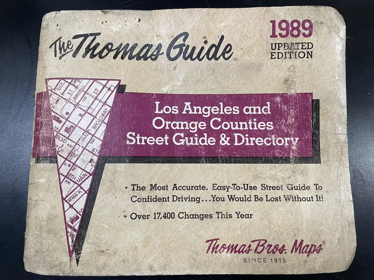
I used a Thomas Guide that was dog-eared and full of Post-it notes to get me through the LA-Orange County area and AAA maps for wider travel. In those days, you really had to plan out your path and jot down notes lest you wind up in a dangerous area. If I lost my way, I'd head to the nearest gas station and ask for directions.
Then, in the early internet days, I'd print out directions from Mapquest.
| by Anonymous | reply 10 | June 4, 2025 3:08 PM
|
MapQuest if I needed point to point directions.
AAA TripTik for vacations.
Always, and still do, keep a map in the car.
| by Anonymous | reply 12 | June 4, 2025 3:11 PM
|
It was a major pain in the ass - but we didn't know any different, that's just how it was.
Besides having detailed instructions spoken to you, the other benefit is having the TRAFFIC integrated into the recommended route. Listening to traffic reports - there used to be stations JUST for traffic updates - was relatively useless. It just told you how bad it was going to be on your route - no other options.
When I first used Google maps or Wayze, I was like - no way, that's not faster. It always was.
Even when you're stuck in traffic and think - maybe I should just go down this side street - Google will tell you whether you should or not - and many times it's worse and you're better off to stay where you are.
Knowing you're on the correct route AND the fastest route is an unbelievable amount of peace of mind - even if you're stuck in traffic. Plus having an estimated arrival time is awesome - it let's you know if you need to call people because you WILL be late in 30 minutes.
And thankfully, Google maps is 98% accurate for me.
| by Anonymous | reply 14 | June 4, 2025 3:14 PM
|
Another vote for Thomas Bros and AAA TripTiks.
| by Anonymous | reply 15 | June 4, 2025 3:18 PM
|
I live in the NYC metro area I had folding paper maps of NY, NJ PA and CT in the glovebox which never held any gloves. Plus a map of New England for occasional trips up to Ptown.
| by Anonymous | reply 16 | June 4, 2025 3:24 PM
|
I got lost often and swore a lot.
| by Anonymous | reply 17 | June 4, 2025 3:26 PM
|
Gen X who's explained this to quite a few Gen Zers - we kept a road atlas in our car. We had to pull over to the side of the road or into a parking lot and look at the atlas, and half the time the fucking street/route you were looking for wasn't in the damn thing. Then you had to find a gas station and ask for directions. It was a HUGE pain in the ass. You'd get lost all the time. GPS is one of the greatest things ever invented.
| by Anonymous | reply 18 | June 4, 2025 3:32 PM
|
I had a little briefcase thing full of atlases and maps. You really needed the closeup detail, to get around the wackiness that is metro Boston.
I learned to drive in the mid 80s, as a teen.
| by Anonymous | reply 19 | June 4, 2025 3:35 PM
|
I would also keep a Rand McNally Road Atlas in the car, though seldom used it. They can still be purchased at Office Depot/Max.
| by Anonymous | reply 20 | June 4, 2025 3:35 PM
|
I wrote down my directions.
| by Anonymous | reply 21 | June 4, 2025 3:40 PM
|
Refolding the map to put it back in the glove compartment was the hardest part.
| by Anonymous | reply 22 | June 4, 2025 3:40 PM
|
Hagstrom maps with laminated pages. Durable, user friendly, and cost a fortune. Perpetual free drinks and blow jobs to the inventor(s) of GPS.
| by Anonymous | reply 23 | June 4, 2025 3:43 PM
|
[quote]AAA gave away a lot of trip tickets.
TripTiks.
You can create your own TripTik online now if you're a member. I've been planning a long driving trip through the five states I've never been to and it's a handy tool.
| by Anonymous | reply 24 | June 4, 2025 3:53 PM
|
I love old road maps. I collected a lot of them (via eBay purchases.) Mostly gas station giveaways from the '40s onward. Fun to look if you're a map nerd like me.
| by Anonymous | reply 25 | June 4, 2025 3:55 PM
|
People used their brains before GPS. Searching for something on a map stimulated the brain and increased intelligence.
| by Anonymous | reply 26 | June 4, 2025 3:57 PM
|
r26 it was an inconvenient pain in the ass, esp. if you were in a time crunch. I don't miss those days at all. Thank god for GPS.
| by Anonymous | reply 27 | June 4, 2025 4:23 PM
|
[quote]Oh honey, I always got lost. I had maps, asked people for directions, even phoned a friend. But, I ALWAYS ended up on the wrong side of town. I have seen more slums than I care to imagine.
Many years ago, before GPS and Smartphones, a friend and I were returning a rental car to the Newark airport and got lost in Newark, NJ at 11:00 at night. We drove around Newark for over an hour until we found the airport. I've been in some bad neighborhoods in my life and never really got scared, but that night in Newark I was truly frightened. I really thought something was going to happen to us.
| by Anonymous | reply 28 | June 4, 2025 4:26 PM
|
I would ask for directions or look at a map.
| by Anonymous | reply 29 | June 4, 2025 4:27 PM
|
Thomas Bros maps are still being published. I bought one a year ago or so for fun. Not cheap, but it’s a great coffee table book!
| by Anonymous | reply 31 | June 4, 2025 4:37 PM
|
Millennial. As a kid, I was often the GPS. Using maps/road atlas and my own good sense of navigation, I would tell whoever was driving what exits and roads to take to get us to the destination as quickly as possible. You also had to
| by Anonymous | reply 32 | June 4, 2025 4:38 PM
|
Read maps. I’m still very good at reading them
| by Anonymous | reply 33 | June 4, 2025 4:42 PM
|
Did we get into more accidents back then, when futzing with folded pieces of paper while attempting to drive?
| by Anonymous | reply 34 | June 4, 2025 4:53 PM
|
I love maps and I love reading them. It really stimulated my brain.
I hate it when my GPS /iPhone changes the orientation (North is UP!!)
We also mapped out the trip beforehand and memorized it as much as we could. Again, good for your brain.
| by Anonymous | reply 35 | June 4, 2025 4:57 PM
|
"Head west, then, turn left!"
Fuck you Google Lady.
| by Anonymous | reply 36 | June 4, 2025 4:59 PM
|
I still don't have it. And I don't have a printer anymore. So when I have a destination for yard sales, etc. I just draw a map on paper using Google.
| by Anonymous | reply 37 | June 4, 2025 5:01 PM
|
Thomas Guides, Maps - get from AAA or gas station; or ask for directions.
| by Anonymous | reply 38 | June 4, 2025 5:05 PM
|
r38 Don't you have a phone?
| by Anonymous | reply 39 | June 4, 2025 5:27 PM
|
R39 how was my rotary wall phone, that I dialed with a pencil going to help me get where i needed to in the car?
| by Anonymous | reply 40 | June 4, 2025 5:30 PM
|
R28 - I remember the press stories of tourists getting lost in dangerous areas of Miami and a few were killed. Some of them were targeted because you could visibly tell it was a rental car.
They made some changes to car identification after that - rental cars used to have brand stickers. Not anymore - they have a fake car dealership name now.
That was almost 30 years ago, but still. Getting lost in a bad neighborhood - and remember NO PHONE! That wasn't a joke. You were prey.
| by Anonymous | reply 41 | June 4, 2025 5:38 PM
|
r41 I remember those stories about Miami, it was usually foreign tourists IIRC. I seriously thought my friend and I were going to get into trouble that night in Newark - scary shit. There are places in this country that look like war zones.
| by Anonymous | reply 42 | June 4, 2025 5:40 PM
|
I hated TripTiks for their linearity and for showing nothing but the route. It was the things off route, at the edges of a proper map that caught my eye: a town that by its streets was clearly old and maybe worth exploring. But not the sprawl of secondary towns and suburbs that flanked an interstate that bisected a city into good and bad halves.
I was a bound atlas man, with fold-out maps for the cities that were my destination. A city of any size would always have a good map store, a place that had been in the same location for 60 years or more, usually with globes and guidebooks, and other travel paraphernalia. If you were lucky, you could find a well annotated bird's-eye view map of a larger city and locate some zones of architectural interest.
I still like maps, but now seriously antique ones of favorite cities showing their unique forms before sprawl set in. For practical purposes, I look online and/or ask the hotel front desk for a map.
| by Anonymous | reply 43 | June 4, 2025 5:48 PM
|
R42 - yep foreign tourists just trying to get to their hotel by the beach, not knowing there's several hoods very close by or that you have to drive through to get there.
Happened to me actually - 1996 on business - late night arrival, got this 1 pager bullshit rental car map and went the wrong direction on the highway. I stuck out like a sore thumb.
I got lost several times on that trip actually. Bought a Rand McNally atlas and kept it with me for the rest of bus travel.
| by Anonymous | reply 44 | June 4, 2025 5:50 PM
|
Enjoying this thread. As a kid, I loved maps, atlases and almanacs so much that I'd ask for for the lastest version at Christmas. Pre-internet, you could call a state's tourism board and ask for one. We never left the house without the big Rand McNally Road Atlases and foldable map of every state we would pass through on the trip. I still have them in storage.
| by Anonymous | reply 45 | June 4, 2025 6:01 PM
|
My father appointed me navigator from a young age. always loved maps. gazing st them was a rainy day pastime.
| by Anonymous | reply 46 | June 4, 2025 6:15 PM
|
I remember lots of pounding my fist at the steering wheel, cursing my zero sense of direction. After my mother died, one of my sisters told me she once said I could get lost in our own subdivision.
| by Anonymous | reply 47 | June 4, 2025 6:21 PM
|
do you travel with younger people using GPS and find they have no sense of where the fuck they are?
if the GPS fails you could end up in Siberia
| by Anonymous | reply 48 | June 4, 2025 6:27 PM
|
Honey in the days of maps you still could end up in fucking Siberia, as did I and many others back then. It's not a generational thing.
| by Anonymous | reply 49 | June 4, 2025 6:29 PM
|
I agree R49
But at least with a map you knew that maybe you were in the state of Missouri?
| by Anonymous | reply 50 | June 4, 2025 6:51 PM
|
Before GPS I think there was Mapquest. Before Mapquest, there were maps. You also have to remember that before the internet, and hotels having a website, it wasn't that easy to find out a lot about where you were going (one reason star ratings were important, I guess). People called or even (before my time) wired ahead for rooms. Many times you called or even wrote a hotel, motel, or campground, asking for directions. My parents didn't belong to AAA and I have no idea what TripTiks are. Still, we managed to get there. There were also guidebooks, of course. Before there were superhighways, travel was more of an adventure. Even in the 70s when my parents and I went to California from New England, the superhighways weren't all completed.
| by Anonymous | reply 51 | June 4, 2025 6:56 PM
|
^By the way, gas stations usually had free maps, at least until the 70s. I still have a couple of Mobil Travel Maps from that trip.
Sometimes, if you weren't going super far, you just took off and found your way using road signs. If you got lost, you did ask directions, at a gas station, grocery store, or somewhere else. To be honest, I don't always use GPs even today. It's good when you really need it, but it can lead you on some convoluted and ridiculous routes. (Down dirt roads, narrow lanes, even dark alleys.)
| by Anonymous | reply 53 | June 4, 2025 7:02 PM
|
there are members of my family who have NO sense of direction.
it is mind boggling...as though it is a genetic defect.
| by Anonymous | reply 54 | June 4, 2025 7:04 PM
|
R54 This has been studied for a while and some people (and many animals) do have more of an innate sense of direction.
| by Anonymous | reply 56 | June 4, 2025 7:09 PM
|
My father sometimes used to do a test drive, if he or one of us had to go somewhere in the city he was unfamiliar with, for an important appointment. Maybe a week before, he's do a trial run.
| by Anonymous | reply 57 | June 4, 2025 7:11 PM
|
You would stop at a Stuckey's and ask for directions. And get a pecan log to snack on in the car.
| by Anonymous | reply 59 | June 4, 2025 7:14 PM
|
Back in the 90s the Thomas Guide was madatory if you moved to LA from Fly over Stan.
| by Anonymous | reply 60 | June 4, 2025 7:15 PM
|
What map app do you like? My husband always used Google Maps until I proved to him that Apple Maps is easier to follow.
| by Anonymous | reply 62 | June 4, 2025 7:25 PM
|
Apple is a better interface. But Google is better for looking places up to then set as the destination. I go back and forth.
Waze is just an absolute mess of busy nonsense on the screen that feels like sensory overload.
| by Anonymous | reply 64 | June 4, 2025 7:36 PM
|
I still use maps, though now they're plotted through Google Maps and printed ahead of time rather than bought in gas stations.
I promised myself I would get GPS with my next new car, but the current one is still going strong at 20 years old.
| by Anonymous | reply 65 | June 4, 2025 8:02 PM
|
r34 No, we didn't. We'd read the map beforehand (not while driving), and memorize "West off freeway at Santa Monica, right on Orange, left on Hawthorn," and if anything went awry we'd pull over and re-read the map.
| by Anonymous | reply 66 | June 4, 2025 8:07 PM
|
OP - you want to hear an even scarier story?
Cars used to break down a lot more in the 70s and 80s. You'd routinely see people on the side of the road with their hood up - on the highways or side streets. Cars were crap quality.
So - your car could breakdown in the middle of an area (perhaps dangerous) you didn't know, with no phone and no idea which direction to go. No friends or family knew where you were.
Sleep tight. Stay tuned for more Eldergay spooky tales.
| by Anonymous | reply 67 | June 4, 2025 8:11 PM
|
r67 I'm old enough to remember those days and it's scary to think about. Things have improved so much in certain ways, I have no nostalgia for a number of things from the past.
| by Anonymous | reply 68 | June 4, 2025 8:13 PM
|
My grandmother was telling me about Mapquest the other day. Sounds complicated.
| by Anonymous | reply 69 | June 4, 2025 8:16 PM
|
Was the Thomas Guide just a Southern California thing, or was it nationwide?
You started by looking up the name of your street in the index. It would say something like "Tuckahoe Street — 68, B-7." Then you'd turn to page 68 and locate the B column and the 7 row.
It mostly worked fine unless it was something like First Street, which could have dozens of entries based on the various municipalities of Southern California.
| by Anonymous | reply 70 | June 4, 2025 8:17 PM
|
Mapquest was also a pain in the ass. You'd have the damn printout in one hand, trying to read it while you were driving, and your other hand on the steering wheel. You'd keep looking back and forth.
| by Anonymous | reply 71 | June 4, 2025 8:18 PM
|
Fought constantly with my husband. If it weren't for GPS we'd be divorced today.
| by Anonymous | reply 72 | June 4, 2025 8:18 PM
|
R67 And California installed Callboxes on every freeway because of that. And yet - they are still there and we all still pay for them to be answered and maintained today!
| by Anonymous | reply 73 | June 4, 2025 8:19 PM
|
I used to drive a taxi. Arrow Road Guide.
| by Anonymous | reply 75 | June 4, 2025 8:20 PM
|
I think we had Rand-McNally guides.
| by Anonymous | reply 76 | June 4, 2025 8:20 PM
|
R70 Most street guides of any city are the same. Even the small town I grew up in had one of those in the back of the town telephone book.
| by Anonymous | reply 77 | June 4, 2025 8:23 PM
|
R27 My elderly mother was told by her doctor to do crossword puzzles and searching for addresses on good old fashion maps in order to slow down her cognitive decline. Enjoy your GPS, iphones and tablets but all this technology is frying your brain. You'll eventually have to go back to what you used to do in the 70s and 80s if you want a healthy brain in your 70s and 80s.
| by Anonymous | reply 78 | June 4, 2025 8:29 PM
|
I was using GPS on my iPhone until I saw that CarPlay screens could be had for as little as $100 these days, so I bought one. Best investment I ever made for my old car. What a difference to have directions read over my car speakers rather than the phone itself. And I like the natural language improvements: "Go past these lights and make a left at the next set ... Use the left two lanes to turn left onto Washington Avenue."
| by Anonymous | reply 79 | June 4, 2025 8:31 PM
|
I used fold-out maps and, eventually, large regional booklets. I love my Garmin. I have her programmed to speak in an English accent. My Mom called her 'Twiggy'.
| by Anonymous | reply 80 | June 4, 2025 8:33 PM
|
I still don't use GPS. If I'm going somewhere unfamiliar I check google maps first. I have a good sense of direction, easily remember where I've been before, and once I look at a map, I remember how to get there.
Outside of my familiar region I use maps. I like maps and the overview I get of my location as it relates to the surrounding areas.
I'm not opposed to GPS, definitely see the benefits, but my car doesn't have it and I haven't tried it with my phone.
| by Anonymous | reply 81 | June 4, 2025 9:28 PM
|
Google Maps and my partner have ruined my once good sense of direction, R81. I now rely on them and find myself a bit stupid now and again, having to look at where my partner is headed or to produce my mobile. Had I studied a map of any sort for a few moments I would have found myself turned around.
Recently though, I was in a large city I had not visited in 30 years and surprised my partner many times by definitively knowing how to get from about, even in fairly complicated routes of many turns. Knowing that a restaurant we wanted to visit was near a particular fountain or plaza or some minor landmark, I could arrive there without missteps. 30-some years ago, pre-Google, I had to devote some time each night to plotting a plan for the next days, consulting and plan and correlating that with hours, etc. to make a sort of big map in my mind. When earned by a bit of study or experience and attention, that sort of visual memory stays with me, as well as a sense of cardinal direction. I can do it if I try, even a little. But lazily following along my partner or Google I sometimes feel quite stupid when I forget the path back, or whether to turn this way or that.
| by Anonymous | reply 82 | June 4, 2025 10:40 PM
|
[quote]Enjoy your GPS, iphones and tablets but all this technology is frying your brain.
Oh just shut the fuck up. Seriously, just shut the fuck up and crawl back into your filthy fucking hovel.
| by Anonymous | reply 83 | June 4, 2025 10:43 PM
|
The other benefit of Google Maps is the street view. I like to know what I'm looking for and what it looks like before I get there. Particularly parking options.
For all the tech that has been developed, this tool has been the most profound time-saving and 'make your life easier' app I can think of. And it's free. (Yes, I know they track where you go, but my life isn't THAT interesting). Fair trade-off - but I would even pay for it.
I also like the timeline where you can go back in your history to places you've visited before on vacations and other trips. I don't use it as much, but it's nice to have.
| by Anonymous | reply 84 | June 4, 2025 10:45 PM
|
I could look at maps all day -- paper maps (a friend taught me the trick to folding them correctly), atlases, London's A To Z(ed) (even though haven't lived there since the late 70s), etc. Like R81, I also have a good sense of direction (and am mystified by people who don't; it is not. that. hard!). That said, as I am often driving alone I do use Google Maps on my phone when I'm going someplace I haven't been before so I don't have to read a paper map and drive at the same time. (And years ago I finally got a phone holder that's inserted in my car's CD drive so I don't have to drive with my phone on my thigh, which was even more of a juggling act when I drove a standard.) Also, I have no shame as a man in pulling over and asking for directions.
Pre-GPS, I used to write up the directions from the airport to my place -- on one sheet of paper, not overly detailed, in largish print -- so if I had friends visiting from out of town I could mail/fax/email it to them ahead of time so they wouldn't have to wrestle with maps or the crap directions from a car-rental agent to get to my apartment. When I lived in Cambridge, MA, my friends were *very* appreciative. I had a second version with directions from my place to the airport and third for visitors driving from, say, New York City or wherever that I could adapt. I earned lots of Good Karma points, and not a few free drinks, with those directions.
| by Anonymous | reply 85 | June 4, 2025 10:47 PM
|
I wish GPS could be programmed in Bette Davis's voice.
| by Anonymous | reply 86 | June 4, 2025 10:50 PM
|
A pic of a Thomas guide does not convey what a pain in the ass it was. That thing was as thick as a book. When I first moved to LA, one of the first things everyone said you had to have in your car. This is what it was like:
| by Anonymous | reply 87 | June 4, 2025 10:53 PM
|
I remember traveling internationally before this tech - you really had to have some skills to navigate a foreign country with no maps and no knowledge of the language.
Now with Google Maps, online reservations, Google translate - going anywhere is 1000x easier and less stressful.
Even finding gay bars in other cities was an event - of course there were gay guides once you got into a bar, but there was a time when many gay bars didn't have big signs and the glass was all darkened.
| by Anonymous | reply 88 | June 4, 2025 10:54 PM
|
R88, what you are talking about is Damron Guide. The Thomas Guide of Gay Bars / Bath Houses / Crusing Spots.
| by Anonymous | reply 89 | June 4, 2025 10:57 PM
|
The other benefit of Google Maps is the street view. I like to know what I'm looking for and what it looks like before I get there. Particularly parking options.
For all the tech that has been developed, this tool has been the most profound time-saving and 'make your life easier' app I can think of.
Agreed, Ri4. Google Maps is a god-damned miracle for me. I use it to choose among possible hotel locations, to check out odd map features to see if they are worth exploring, to select walking routes, or to find a restaurant.
I use it almost every day in my real estate obsession, checking out the street views and exploring surroundings for houses for sale. A bit of street view scouting and many houses be dismissed or deemed interesting straight away because of what shows up in the immediate vicinity. I can usually triangulate a house where only a vague location is given and decide if it's worth following through on or if it's on a street or section of a neighborhood that's ugly or a bit rough looking.
| by Anonymous | reply 90 | June 4, 2025 11:07 PM
|
Street view is the true innovation. But some older people think it's perpetual and invasive.
| by Anonymous | reply 91 | June 4, 2025 11:13 PM
|
Some people actually contact Google and are able to have the street view of their house blurred out. Every time I stumble on that my first though is Drug House. Sure enough, there are usually a high number of expensive cars parked near by that do NOT match the demographics of that neighborhood.
| by Anonymous | reply 92 | June 4, 2025 11:17 PM
|
Funny r92! My friends and I have been saying the same thing for years. People who want their houses blurred out are usually getting up to some shit.
| by Anonymous | reply 93 | June 4, 2025 11:20 PM
|
AAA Trip-Tiks up and down the east coast bringing the Fleetwood/Town Car/98 Regency/Volvo down to Florida and back so Mom could fly and skip the ride. We’d open up the house and then flew home. Twice a year every year for a decade.
| by Anonymous | reply 94 | June 4, 2025 11:21 PM
|
R94 - I would have put her ass on the Florida car train and said call me when you get there!
It's been active since 1971.
| by Anonymous | reply 95 | June 4, 2025 11:26 PM
|
R92 I would say that, but I have gotten at least a dozen creepy as fuck emails that basically somehow combed my name and address and put together a threatening letter complete with pictures of my house. Demanding money, etc.
Really freaked me out the first time I got one of these. I kind of get not wanting pics of my house out there.
| by Anonymous | reply 96 | June 5, 2025 12:30 AM
|
R96 - never heard of that. But yeah - I was tired of having my name, age, cell number and addresses easily available on the internet. I particularly didn't like my name and age coming up on the first page when I was applying for jobs.
I used a service called DeleteMe and it's all gone now. Took a couple of months - but I like that nobody sees anything about me but my LinkedIn when they search my name.
| by Anonymous | reply 97 | June 5, 2025 12:33 AM
|
You bitches almost made me buy a Thomas guide - but it’s $45 on Amazon, that’s too much.
| by Anonymous | reply 98 | June 5, 2025 1:11 PM
|
What's best for walking the streets of London? I find that Google Maps isn't so great over there but it is admittedly challenging with the lack of street signage and the way streets suddenly change names.
Forgive me if this has already been covered upthread; I haven't read all the posts.
| by Anonymous | reply 99 | June 5, 2025 1:13 PM
|
I was good at maps. The key is to keep track of where you are at all times by reference to the map. Periodically confirm that what the map shows is just ahead of you is in fact what you see.
If you lose track of where you are on the map and only look at the map when you are lost, your odds of remaining lost are much higher.
When relying on directions given by another person, you were dependent on how well they advised you about potential mistakes. Once you made a wrong turn or missed a turn you had to find your way back to the original route to get back on track.
| by Anonymous | reply 100 | June 5, 2025 1:20 PM
|
I’ve seen reference to AAA Triptiks, but I’m not sure anyone has shown what they were (and apparently ARE!) You’d call AAA before a long road trip and tell them where you were going and they’d map out your route for you in a handy booklet. You’d flip each page where you got to the end of the route on that page and the next page would be the continuation.
| by Anonymous | reply 101 | June 5, 2025 1:30 PM
|
[quote]What's best for walking the streets of London?
Lee Ho Fook's restaurant guide.
| by Anonymous | reply 104 | June 5, 2025 10:03 PM
|
I still keep a huge book of maps in my trunk that I replace with a new one every 3 years. I'm now old and don't drive much anymore, at least to places I don't know how to easily get there, but that big book of maps gives me comfort.
| by Anonymous | reply 105 | June 5, 2025 10:39 PM
|
The New Yorker’s way to drive to Chicago:
Get a cab going uptown, cross the George Washington Bridge, drive 700 miles west and then ask someone.
| by Anonymous | reply 106 | June 5, 2025 10:41 PM
|
[quote] Some people actually contact Google and are able to have the street view of their house blurred out. Every time I stumble on that my first though is Drug House. Sure enough, there are usually a high number of expensive cars parked near by that do NOT match the demographics of that neighborhood.
The house I grew up in is blurred out on Google but it's not a drug house (or Drug House). Your theory seemas a bit paranoid.
| by Anonymous | reply 107 | June 6, 2025 12:11 AM
|
[quote]What's best for walking the streets of London?
Hire a streetwalker.
| by Anonymous | reply 108 | June 6, 2025 1:37 AM
|
R106 - that's actually pretty accurate. But it's 800 miles. 12 hours - somehow NY and Chicago feel further apart in distance than that, but I've done it and it isn't.
| by Anonymous | reply 109 | June 6, 2025 1:43 AM
|
Being a New Yorker, R106, you’d look outside the cab in Indiana, say “WTF am we doing here” and start asking well before reaching the Illinois line.
| by Anonymous | reply 110 | June 6, 2025 11:12 AM
|
I love maps. Whenever I’d go to Europe, the first place I’d go to when I arrived in a town was the tourist office. Even small towns had them and they always had free maps. My last visit I did the same even though I’d downloaded a bunch of maps onto my phone to use offline. It is still much easier to use a big map than a tiny screen if you’re going to places far apart. The funny thing is, many of the tourists I saw were also carrying and consulting the tourist office map instead of phone screens.
Long ago when I was a backpacker hitchhiking and staying in hostels (also everywhere) even the tiniest villages in France had “plan de ville” signs on the edge of town. It was a map showing the location of all the important things including the tourist office and the hostel. I used to quickly draw it in my notebook and then proceed to walk in. It was great. They’re probably all gone now.
| by Anonymous | reply 111 | June 6, 2025 11:44 AM
|
It was a whole THING, OP. Don’t ask.
| by Anonymous | reply 112 | June 6, 2025 12:41 PM
|
But you may ask - how did you know if the place was open? What was on the menu? You DIDN'T know. You could call for the open hours - which meant dialing 411 for information or using the phone book. As far as the menu - it was a SURPRISE!
And if you were running late to meet someone - the other person just waited and got mad at you. If you hit traffic or couldn't find parking - it was somewhat understood, but still annoying.
Sometimes you completely missed another person - you were on the other side of X establishment or had gone to the bathroom and weren't there when they got there.
And while you waited, there was nothing to do. No phone to look at. You just looked out the window or stared at your watch.
| by Anonymous | reply 113 | June 6, 2025 2:18 PM
|
[quote] And while you waited, there was nothing to do. No phone to look at. You just looked out the window or stared at your watch.
That's what magazines were for
| by Anonymous | reply 114 | June 6, 2025 2:23 PM
|
R114 - if you brought your own - there weren't stacks of free magazines in restaurants or bars. And who's going to bring a magazine with them to a bar or club or even a restaurant?
| by Anonymous | reply 115 | June 6, 2025 2:40 PM
|
Rand McNally map in the car.
| by Anonymous | reply 116 | June 6, 2025 3:11 PM
|
Menus, believe it or not, were published in the telephone book. Mostly sandwich, pizza, Chinese and some casual dining places. It was so you could phone in an order. Kinda like today.
Waiting? That’s what paperback books were for. Years ago I remember writer Antonia Fraser saying she always carried two, in case she finished the first one.
| by Anonymous | reply 117 | June 6, 2025 4:16 PM
|
Oh, the number of family vacations ruined by poor map reading skills... my father would start by getting nervous and hesitating to pull over, then the forehead to hands on the steering wheel, finally climaxing with the pulling off the highway, desperately looking for a place to stop so he could take out the map, unfold it across the hood of the car, and ponder our existence. Meanwhile, two crying children in the back seat had to be repeatedly told no, we weren't lost and would eventually find wherever it was we were headed... usually, the next freeway exit away.
| by Anonymous | reply 118 | June 6, 2025 4:21 PM
|
We consulted our scrolls and were guided by the sun and the circumpolar stars. Whenever I got turned around in my chariot, I would remind myself, "Keep Ursa Major on your left and Pleiades on your right."
| by Anonymous | reply 119 | June 6, 2025 4:33 PM
|
R92 some celebrities have their house blurred too.
I also recently watched Whatever Happened to Baby Jane again, and I looked up the house they used for the exteriors. When I went to Street View to look at the address, it was also blurred. I wonder if someone who lives there was tired of people driving by taking photos of their "famous house"... ?
172 McCadden Pl, Los Angeles, CA 90004
| by Anonymous | reply 120 | June 6, 2025 5:20 PM
|
R117 - that was a limited menu though and like you said - take-away or delivery only.
TRIGGER WARNING - Here's another tale from the ElderGay scary crypt - when you got to a restaurant, nothing was identified as Vegan, gluten-free, sourcefully grown, or anything else. Changes to dishes were rare or not allowed. And unless you specifically sourced a vegetarian restaurant ahead of time - (which were uncommon) - there may not be anything vegan or vegetarian to eat!
Sounds hard to believe - but I swear it's true. Gives millenials and Gen Z chills down their spine. BOO!
| by Anonymous | reply 121 | June 6, 2025 6:02 PM
|
R120 South McCadden Place. It makes a difference in those streets…
| by Anonymous | reply 122 | June 6, 2025 6:09 PM
|
Or North…sixes and sevens
| by Anonymous | reply 123 | June 6, 2025 6:14 PM
|
I wandered lonely as a cloud
| by Anonymous | reply 124 | June 6, 2025 9:04 PM
|
R115: Years (decades...) ago in Boston I was meeting a good friend for an afternoon drink at a gay bar (don't remember which one, but it's probably gone now). He was late (as always) so I read my book at the bar while I waited for him. When he got there he said, "Why are you reading a book? You'll never meet anyone that way." I said, "Look around, see anyone you want to talk to?" He said he didn't; I said, "The defense rests."
| by Anonymous | reply 125 | June 6, 2025 10:12 PM
|
[quote]And while you waited, there was nothing to do. No phone to look at. You just looked out the window or stared at your watch.
Or smoke a cigarette.
"Excuse me, can I get an ashtray? Oh, and some matches too?"
| by Anonymous | reply 126 | June 6, 2025 10:14 PM
|
R126 - lol - very true. God, I remember when you could smoke in bars and clubs - it seems so long ago, but it really wasn't - maybe 15 years ago? 20 - depending on the area?
| by Anonymous | reply 127 | June 6, 2025 10:33 PM
|
Maps are still good for general directional info, plus they will tell you your exit number and so forth. I have been betrayed by google so many times. 4 seconds AFTER I've sailed past a freeway exit, the little phone voice will say, "Exit at so and so". Then 3 seconds later, "Recalculating". Then, "take the next exit and then turn left to cross the freeway". GRRR - infuriating.
I'm often surprised by people who are totally unaware of how they could possibly figure out what direction they're headed in. THAT'S WHY WE HAVE THS SUN, PEOPLE! Granted, it doesn't help with night driving - but still. Even if a freeway is traveling on a diagonal, rather than due North, South, East, or West, if the sun is generally in your eyes in the morning, you're headed in an eastward direction. If it's generally in your eyes in the late afternoon, you're headed west. If it's off to your right in the morning, you're headed north, If it's off to your left in the morning, you're headed south. And reverse those if you're traveling in the late afternoon.
| by Anonymous | reply 128 | June 6, 2025 11:39 PM
|
R128 - the Google voice has never spoken to me after an exit - but only not soon enough to get into a turn lane during heavy traffic. That's why I generally eye the screen as well because it will tell you the distance before a left or right turn. I don't ever wait until the voice speaks.
Some people are just not born with a sense of direction - I've met them. I've always liked 'knowing' where I am - even when I travel and where I am in relation to a map and other areas. Others don't care or don't seem to have the ability.
| by Anonymous | reply 129 | June 7, 2025 12:29 AM
|
FFS, any property owner can request blurring of the Google Maps Street View image of their property. You don't have to be a celebrity or in a witness protection program or have any extraordinary circumstances or need. You demonstrate that you are the owner, fill out a online request form, and submit. That's the process.
You have to state the reason for the request, but a simple "to preserve privacy" or anything of the sort will do.
| by Anonymous | reply 130 | June 7, 2025 2:04 PM
|
I grew up in Chicago, a Cartesian city, all I needed was an address.
But then I moved to LA and added a half hour of getting lost to the 3 hours I'd spend on a freeway.
| by Anonymous | reply 131 | June 7, 2025 2:37 PM
|
People who have their houses blurred are just SO SPECIAL. Bitches, nobody is checking for you.
| by Anonymous | reply 132 | June 7, 2025 3:25 PM
|
Mapso. For longer trips, AAA trip-ticks (sp), but it only worked if you had someone else in the car to tell you where/when to turn. OR You did trip in segments and stopped every once in a while to jot down/memorize names of turn-offs, etc.
| by Anonymous | reply 133 | June 7, 2025 3:28 PM
|
R130, I used to be able to view my home in Street View, but recently, when I search my home address, it takes me to the house next door, then skips my house and the next three houses when I arrow left. What gives? I'm wondering it this is just a bug in the system and not some privacy request.
| by Anonymous | reply 134 | June 7, 2025 4:35 PM
|
Back in my day, we listened to the sound of our own farts.
| by Anonymous | reply 135 | June 7, 2025 4:53 PM
|
How much before GPS? For many years there were online mapping sites that would route your destination and print it out. Before that, there were maps. Also intelligence.
As a boy in the 60s and 70s, I developed a normal, good sense of direction. This happens between 9 and 12 years old, in ancient times, before the intertubes. I could give directions from my house in Connecticut to our house on the Cape, for example. Sitting in the car with a relative. I could read maps, do math in my head, read above my grade level and enjoy it. I could play an instrument, read music of course, and cook food, and play well on a sports team. Remember those days? We also said please and thank you. I'm sure most of you were the same.
| by Anonymous | reply 136 | June 7, 2025 4:55 PM
|
R134. I think that is due only to the inexact quality of Street View photography. It could be down to something as simple as a large truck passing or blocking the intended image; the tightness of a narrow street that results in gaps; the inexact process of stitching together separate images or frames...
It's likely a technical issue of that particular date of Street View image collection. I see similar gaps often, that don't appear intentional, just a glitch of the Google Maps data update. And it's common for a Street View of a, say six block long street, to not include s good image of every facade along the way. Blurring, though, is clearly intentional.
| by Anonymous | reply 137 | June 7, 2025 5:08 PM
|
The finance guy in my old office got very clearly and recognizably photographed walking along the residential street that links his parking lot with the office. He’s tall and skinny and slouchy and the angle of the Google cam on the car made him look slouchier but he liked the picture enough to print it and hang it in his office.
| by Anonymous | reply 138 | June 7, 2025 7:11 PM
|
For years you could see my aunt in her driveway on G-maps, in Arlington MA.
| by Anonymous | reply 139 | June 8, 2025 5:08 PM
|
R137 - yes - they also will block some things if there's an offensive or controversial sign outside a residence or if someone driving past flips the bird or makes a face. I've seen that - and I've seen the Google maps cars twice with people following it around.
Note to Google - it doesn't help to have your logo blasted on the side of the device and car.
| by Anonymous | reply 140 | June 8, 2025 5:13 PM
|
[quote]Note to Google - it doesn't help to have your logo blasted on the side of the device and car.
If I recall, the logos were not on the cars originally, but added later? I imagine the logo not only inspires some criticism but also wards off a good many nosey or stupid questions.
| by Anonymous | reply 141 | June 8, 2025 6:12 PM
|
R141 - yes, originally they weren't marked - but I've seen two that were.
| by Anonymous | reply 142 | June 8, 2025 8:12 PM
|
Remember that viral street address with a random guy laying face down half on the sidewalk half in the street? I forget what the story was, drunk or just pranking.
| by Anonymous | reply 143 | June 8, 2025 9:06 PM
|
R117 I'm guessing Antonia had a purse to carry her paperback in.
If you wanted something to read in the city if you were anticipating having to wait for someone (at least in my experience) you'd pick up a newspaper, which was much easier than buying a magazine. There were usually newspaper boxes everywhere.
| by Anonymous | reply 145 | June 10, 2025 7:08 PM
|
But lots of times you just had to sit there and wait.
| by Anonymous | reply 146 | June 10, 2025 7:09 PM
|